
The Plott Balsams WESTERN NORTH CAROLINA
Nantahala National Forest
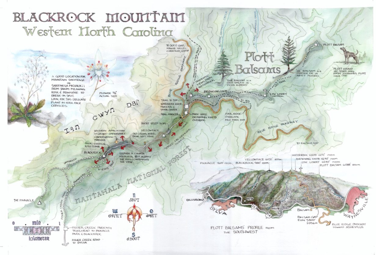
Since 2013, I have been illustrating maps in Haywood County pro-bono with HCTDA (Haywood County Tourist Development Authority) and Buy Haywood, an organization supporting locally home grown products. The goal is to develop a more sustainable community; whose ecological, economic and sociological awareness helps them become self-supportive. The method of communication is simple. Put one page of information together to get tourists and the community hooked on local assets on the reverse side of an illustrated map showing the physical features of an area.We are indeed fortunate here to have such a diverse environmental region in the Blue Ridge to do this. The latest creation is an illustrated map of the Plott Balsams. The story on the back concentrates on conservation efforts, along with other cultural and environmental issues. Following this introduction is a copy of the narrative from the map regarding Haywood County and the Plott Balsams.
We probably all realize how depleted the State funding is for environmental concerns. It started in the previous administration when Governor Purdue used funds from land and water conservation efforts to balance the State deficit. Since then, funding for these efforts has never recovered. Land conservation organizations in the State need to pool resources from several outside sources to continue efforts. Water, one of our most important resources, is at risk. Local communities are challenged by development and lack of restoration easements around the tributaries and headwaters. Conservation efforts in our region have been strong and through the diligence of organizations like SAHC (Southern Appalachian Highland Conservancy) and The Conservation Fund, headway is being made despite the lack of funding. These groups are extremely creative and determined to pull resources together to ensure a legacy.
On Tuesday, May 10th, at 5:30 PM, at the West Asheville Public Library, the Blue Ridge Naturalist Network will be hosting SAHC on a presentation regarding Land Conservation Goals in Western North Carolina. It is free of charge and open to the public. All are welcome!
Ken Czarnomski, Architerct, BRNN ,VP of the Blue Ridge Naturalist Network
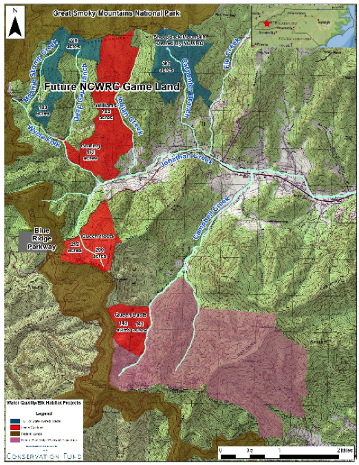
The Conservation Fund map for the Balsams and Plott Balsams in Haywood County
CONSERVATION PROTECTS LAND, WATER, WILDLIFE
Three mountain ranges compose what is understood to be the Balsam Ridge. The Plott Balsams (the focus of this map) are bordered by the Balsam Mountains located to the north along the border of the Great Smoky Mountains National Park and by the Greater Balsams located to the south from Balsam Gap toward Asheville. The Blue Ridge Parkway travels along much of the Balsam Ridge. Often the Parkway property is only a few hundred yards wide. Development, roadways and tree clearing have continued to press the surrounding borders. There is a need for a protected corridor and a unification of this impressive ridge line.
Bill Holman, North Carolina Director for The Conservation Fund, pointed out that the Balsams serve as a critical watershed, wildlife corridor and recreational asset which impacts the economic sustainability of the surrounding local towns like Maggie Valley, Waynesville, Sylva and Cherokee.
Four conservation organizations standout and have taken the lead for land acquisition in the Plott Balsams. They are the Southern Appalachian Highlands Conservancy (or SAHC), The Conservation Fund, The Nature Conservancy and the Conservation Trust For North Carolina (CTNC). State allocated funds, such as the Clean Water Management Trust Fund, add additional financial support.
A large consolidation of The Conservation Fund protected properties lie east of the Blue Ridge Parkway along the ridge between Waterrock Knob and Plott Balsam Mountain. The second section lies west the Blue Ridge Parkway continuing along the Plott Balsam Ridge toward Blackrock Mountain. Another 200 acres is protected by the Southern Appalachian Land Conservancy (SAHC). Together, the property held in conservation will provide a rare opportunity in Haywood and Jackson Counties for expansion of the Blue Ridge Parkway corridor. This is significant since over 5000 acres of high elevation ecology can be enjoyed by the public while protecting our water resources and wildlife and contributing economically to the future of the surrounding towns.
The Plott Balsams and the Greater Balsams supply drinking water to three areas: Dill’s Creek, Sylva’s primary drinking water source; Allen’s Creek watershed, which supplies Waynesville; and Campbell Creek which provides Maggie Valley’s water. The most recent conservation land acquisitions in the Plott Balsams protect the West and East Prong of Campbell Creek along their headwaters from Waterrock Knob and Plott Balsam Mountain. Additionally, land acquired through the same conservation efforts provide for future NCWRC (North Carolina Wildlife Resource Commission) Game Land protecting the creeks leading into Johnathan Creek, named after Johannes Plott, that run directly through Maggie Valley.
Funds for these efforts are raised predominately through private contribution and bargain sales by conservation minded landowners. These properties, through private trusts, ensure no future development. Refer to the Acknowledgements for Web Sites and more detail. www.conservationfund.org et al
Map and article by Ken Czarnomski, guest blogger